Open Source Intelligence (OSINT) is the practice of collecting and analyzing publicly available data for intelligence purposes. One fascinating and practical use of OSINT is ship tracking — monitoring the movement, identity, and status of vessels around the world using open data.
Whether you're a maritime enthusiast, journalist, analyst, or just curious, this guide will walk you through the basics and also give you high-level tips used by professionals.
🌍 Why Track Ships?
Tracking ships can be useful for:
- Journalism: Investigating maritime incidents or sanctions evasion.
- Security research: Monitoring military or strategic naval activity.
- Environmental studies: Watching fishing vessels in protected zones.
- Business intelligence: Understanding global trade patterns.
- Hobbyists: Watching cruise ships, tracking rare vessels, or studying naval operations.
🧭 The Basics: How Ships Are Tracked
Ships are tracked primarily through a system called AIS (Automatic Identification System). This system uses radio signals to broadcast a ship's identity, position, speed, course, and other data. AIS is mandated for most commercial ships over 300 gross tons and all passenger vessels.
🔑 Key Concepts in Ship Tracking
Before diving into tools and techniques, let's cover some foundational concepts.
1. Automatic Identification System (AIS)
AIS is a tracking system used by ships to broadcast their position, speed, course, and other details via VHF radio signals. Mandated by the International Maritime Organization (IMO) for most commercial vessels over 300 gross tons, AIS data is publicly available through various platforms.
What AIS Provides:
- MMSI Number: A unique identifier for each ship (Maritime Mobile Service Identity).
- IMO Number: A permanent identifier for ships, unlike MMSI, which can change.
- Vessel Name, Type, and Flag: Details about the ship's identity and country of registration.
- Position: Latitude and longitude coordinates.
- Speed and Course: Current speed (in knots) and direction.
- Destination and ETA: Reported destination port and estimated time of arrival.
- Ships can disable AIS (known as "going dark"), often for legitimate reasons (e.g., avoiding pirates) or illicit ones (e.g., sanctions evasion).
- Not all vessels are required to use AIS (e.g., small boats or military ships).
- AIS data can be spoofed, where ships broadcast false locations or identities.
🚤 Types of Vessels
Understanding vessel types helps contextualize tracking data:
- Cargo Ships: Carry goods (e.g., containers, bulk carriers for grain or coal).
- Tankers: Transport liquids (e.g., oil, LNG, chemicals).
- Passenger Ships: Ferries or cruise ships.
- Fishing Vessels: Commercial fishing boats, sometimes involved in illegal fishing.
- Military Vessels: Often exempt from AIS requirements but may broadcast voluntarily.
- Yachts and Pleasure Craft: Private vessels, often tracked for high-profile owners.
🛠️ Tools for Tracking Ships with OSINT
Here's a detailed look at the most accessible and beginner-friendly tools for ship tracking, along with tips for using them effectively.
1. MarineTraffic
Overview: MarineTraffic is one of the most popular platforms for real-time ship tracking, aggregating AIS data from a global network of receivers.
Features:
- Interactive map showing ship positions worldwide.
- Search by vessel name, MMSI, or IMO number.
- Vessel details, including type, flag, dimensions, and recent ports of call.
- Historical voyage data (limited in free version).
- Mobile apps for iOS and Android.
How to Use:
- Visit www.marinetraffic.com or download the app.
- Use the search bar to find a ship by name, MMSI, or IMO.
- Click a ship icon on the map to view details like position, speed, and destination.
- Explore filters (e.g., vessel type or port) to narrow your focus.
2. VesselFinder
Overview: Similar to MarineTraffic, VesselFinder offers real-time AIS tracking with a user-friendly interface.
Features:
- Global ship tracking map.
- Vessel details, including photos submitted by users.
- Port activity and expected arrivals.
- Free and paid versions.
How to Use:
- Go to www.vesselfinder.com.
- Search for a vessel or browse the map.
- Click a ship to view its AIS data and voyage history.
- Use the "Ports" tab to monitor activity in specific regions.
3. FleetMon
Overview: FleetMon focuses on commercial shipping and provides detailed vessel and port data.
Features:
- AIS-based tracking with a focus on cargo and tanker fleets.
- Port call schedules and trade pattern analysis.
- Vessel photos and technical details.
How to Use:
- Visit www.fleetmon.com.
- Sign up for a free account to access basic tracking.
- Use the search tool or map to locate vessels.
4. Satellite Imagery Platforms
Overview: For ships not broadcasting AIS or in remote areas, satellite imagery can provide visual confirmation. Platforms like Sentinel Hub or Google Earth Pro offer free or low-cost options.
Features:
- Access to recent satellite images (Sentinel Hub uses Copernicus Sentinel data).
- Ability to analyze specific coordinates or ports.
- Historical imagery for tracking past movements.
How to Use:
- Visit www.sentinel-hub.com and sign up for a free account.
- Use the EO Browser to select a date and location (e.g., a port or coordinates from AIS data).
- Analyze images for ship presence or activity.
5. Social Media and Crowdsourced Data
Overview: Platforms like X, Reddit, or maritime forums can provide real-time tips, photos, or reports about ship movements.
How to Use:
- Search X for keywords like "[ship name] sighting" or "[port name] activity."
- Join maritime communities on Reddit (e.g., r/Shipping or r/Maritime).
- Follow accounts or hashtags related to shipping (#AIS, #Maritime).
6. Ship Registries and Databases
Overview: Public ship registries provide detailed information about a vessel's ownership, flag, and technical specifications.
Key Resources:
- Equasis: Offers free access to ship data, including inspections and ownership.
- IMO GISIS: The IMO's Global Integrated Shipping Information System provides official ship records.
- Clarksons Research: A paid database with extensive shipping data.
- Ownership data can reveal links to companies involved in suspicious activities.
- Check inspection reports for safety or compliance issues.
🧠 Advanced OSINT Tactics
🛰️ 1. Detecting AIS Spoofing
What It Is: AIS spoofing is when a ship deliberately broadcasts a false location, identity, or destination to hide its true activity — often for sanctions evasion, smuggling, or military concealment.
How to Spot It:
- Cross-check AIS data with satellite imagery (e.g., from Sentinel Hub or Skylight).
- Look for jumps in location that don't match the ship's speed or prior heading.
- Use Skylight to visualize anomalies in movement patterns or identity conflicts.
- Two ships using the same MMSI at different locations.
- A ship reporting it's docked, but satellite imagery shows open water.
- Location changes that suggest the ship "teleported" thousands of kilometers in hours.
Example: A tanker reports being in Singapore, but a satellite image reveals it near Somalia — likely trying to mask an illicit fuel transfer in the Horn of Africa.
🕳️ 2. Tracking "Dark" Vessels
What It Is: A "dark" vessel is a ship that has turned off its AIS transponder, making it invisible to most tracking platforms. This often happens near conflict zones, sanctioned waters, or during illegal transfers.
How to Track:
- Review the last known AIS point and estimate travel range using heading and speed.
- Use satellite imagery to visually search for ships in the expected area.
- Monitor social media, Telegram groups, or local news for eyewitness reports.
Tools to Use:
Example: A fishing vessel goes dark near a marine protected area off South America. Sentinel imagery from the next day reveals a small vessel operating within the no-fishing zone.
🕵️♀️ 3. Analyzing Ownership Networks
What It Is: Ships often change names, flags, and companies to hide their real owners. Tracing ownership networks can uncover links to illicit trade, sanctions evasion, or money laundering.
How to Investigate:
- Look up the ship's IMO number on Equasis or Clarksons.
- Search for the owning/operating company on OpenCorporates.
- Use government sanctions lists (e.g., OFAC, UN, EU) to see if those companies are restricted entities.
- Check for frequent changes of flag or ownership, which may indicate front companies or attempts to obfuscate.
Example: You find that the company behind the tanker Ocean Star is registered in the Marshall Islands, with a corporate director also linked to a shipping firm under US sanctions for trading with North Korea.
📍 4. Geofencing and Alerts
What It Is: Geofencing is the practice of defining virtual boundaries on a map to get real-time alerts when a ship enters or exits that zone. Ideal for monitoring sensitive ports, restricted waters, or choke points.
How to Set It Up:
- Use tools like MarineTraffic or FleetMon (paid plans required).
- Draw a custom zone around your area of interest (e.g., near Iranian ports or off the coast of Venezuela).
- Configure alerts for specific ships or ship types.
Use Cases:
- Monitor tankers entering sanctioned waters.
- Get notified when military ships dock in foreign ports.
- Track movements near disputed maritime zones.
Example: You receive an alert when Ocean Star crosses into a high-risk port in Libya known for illegal oil exports. That movement suggests possible violations of embargo laws.
⚠️ Legal and Ethical Considerations
Tracking ships via public AIS data is legal in most jurisdictions, but be aware:
- Do not interfere with maritime operations.
- Don't rely solely on AIS — data can be spoofed, turned off, or delayed.
- Be cautious about publishing movement of military or sensitive vessels, especially during conflict or operations.
🛠️ Real-World Example: Sanctions Evasion
Let's say you want to investigate a tanker suspected of violating oil sanctions:
- Find the IMO number via news or watchlist.
- Use MarineTraffic or VesselFinder to check past movements.
- Look for dark periods or STS transfers near sanctioned regions.
- Use Sentinel Hub EO Browser to examine satellite imagery from those dates.
- Check ownership via Equasis.
- Use corporate registries (e.g., Panama, Marshall Islands) to trace shell companies.
- Monitor port calls in regions of interest (e.g., Syria, North Korea).
💻 Build Your Own Marine Tracking System Using Python + APIs
What It Is: Instead of relying solely on platforms like MarineTraffic or VesselFinder, you can build your own lightweight tracking tool using Python and various maritime APIs. This gives you more control, custom automation, and the power to integrate data across platforms.
What You'll Need:
- Python (3.9+)
- Libraries: requests, pandas, folium, geopandas, datetime
- APIs (Free or low-cost options):
- MarineTraffic API
- FleetMon API
- AIS Hub Feed
- Global Fishing Watch
- OpenSeaMap tiles
Install Dependencies:
pip install flask requests pandas folium geopandas datetimeStep 1: Set Up Your Flask Project
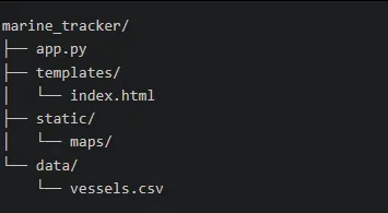
Create a project structure to keep things organized.
app.py
from flask import Flask, render_template
import requests
import pandas as pd
import folium
import geopandas as gpd
from datetime import datetime
import os

app = Flask(__name__)

# Function to fetch data from MarineTraffic API
def get_marinetraffic_data(api_key, area):
    url = f"https://services.marinetraffic.com/api/exportvessels/{api_key}"
    params = {
        'timespan': 10,
        'area': area,
        'protocol': 'json'
    }
    try:
        response = requests.get(url, params=params)
        if response.status_code == 200:
            return response.json()
        else:
            print(f"MarineTraffic API error: {response.status_code}")
            return []
    except Exception as e:
        print(f"Error fetching MarineTraffic data: {e}")
        return []

# Function to fetch data from FleetMon API
def get_fleetmon_data(api_key):
    url = f"https://www.fleetmon.com/api/v1/vessels/{api_key}"
    try:
        response = requests.get(url)
        if response.status_code == 200:
            return response.json()
        else:
            print(f"FleetMon API error: {response.status_code}")
            return []
    except Exception as e:
        print(f"Error fetching FleetMon data: {e}")
        return []

# Function to aggregate AIS data from multiple APIs
def fetch_ais_data():
    data = []

    mt_api_key = os.environ.get('MARINETRAFFIC_API_KEY', 'YOUR_MT_API_KEY')
    mt_data = get_marinetraffic_data(mt_api_key, 'MED')
    for vessel in mt_data:
        try:
            data.append({
                'mmsi': vessel.get('MMSI'),
                'name': vessel.get('SHIPNAME', 'Unknown'),
                'lat': float(vessel.get('LAT')),
                'lon': float(vessel.get('LON')),
                'speed': vessel.get('SPEED', 0),
                'timestamp': vessel.get('LAST_POS',
                    datetime.utcnow().isoformat())
            })
        except (ValueError, TypeError):
            continue

    fm_api_key = os.environ.get('FLEETMON_API_KEY', 'YOUR_FM_API_KEY')
    fm_data = get_fleetmon_data(fm_api_key)

    df = pd.DataFrame(data)
    if not df.empty:
        df['timestamp'] = pd.to_datetime(df['timestamp'])
    return df

# Function to create interactive map with Folium
def create_map(df):
    m = folium.Map(location=[35.0, 15.0], zoom_start=5, tiles=None)

    folium.TileLayer(
        tiles='https://tiles.openseamap.org/seamark/{z}/{x}/{y}.png',
        attr='OpenSeaMap',
        name='OpenSeaMap'
    ).add_to(m)

    folium.TileLayer('openstreetmap').add_to(m)

    for _, row in df.iterrows():
        try:
            folium.Marker(
                location=[row['lat'], row['lon']],
                popup=f"{row['name']} (MMSI: {row['mmsi']})"
                      f"<br>Speed: {row['speed']} knots",
                icon=folium.Icon(icon='ship', prefix='fa',
                    color='blue')
            ).add_to(m)
        except (KeyError, ValueError):
            continue

    folium.LayerControl().add_to(m)

    os.makedirs('static/maps', exist_ok=True)
    map_path = 'maps/vessel_map.html'
    m.save(f'static/{map_path}')
    return map_path

# Flask route
@app.route('/')
def index():
    try:
        df = fetch_ais_data()
        if not df.empty:
            df.to_csv('data/vessels.csv', index=False)
    except Exception as e:
        print(f"Error fetching data: {e}")
        try:
            df = pd.read_csv('data/vessels.csv')
        except FileNotFoundError:
            df = pd.DataFrame()

    map_path = create_map(df) if not df.empty \
        else 'maps/empty_map.html'
    return render_template('index.html', map_path=map_path)

if __name__ == '__main__':
    os.makedirs('data', exist_ok=True)
    app.run(debug=True)
index.html (template)
<!DOCTYPE html>
<html>
<head>
    <title>Marine Tracker 🌊</title>
    <style>
        #map { height: 600px; width: 100%; }
        body { font-family: monospace; margin: 20px; }
        h1 { color: #00ffff; }
    </style>
</head>
<body>
    <h1>Real-Time Ship Tracking 🚢</h1>
    <div id="map">
        <iframe
            src="{{ url_for('static', filename=map_path) }}"
            width="100%" height="600px"
            frameborder="0">
        </iframe>
    </div>
    <p>Data updates every 5 minutes.</p>
    <script>
        function refreshMap() {
            document.querySelector('iframe')
                .contentWindow.location.reload();
        }
        setInterval(refreshMap, 300000);
    </script>
</body>
</html>
⛴️ Final Thoughts
Tracking ships using OSINT combines real-time data, analytical thinking, and detective work. You don't need expensive tools to get started — just curiosity and methodical research. As global shipping remains the backbone of trade and geopolitics, understanding how to follow the movements of vessels across the oceans gives you a powerful lens into world affairs.
5iyhsb1SPWEzapMmDTKWRV...
[Copy]